Concept of remote sensing for environmental health
"Environmental health remote sensing" refers to the use of multi-source remote sensing data to realize the macro control to the effect of environmental health factors, and makes a comprehensive evaluation on environmental health, in order to effectively analyze the spatial and temporal characteristics of global and regional scale environmental health and its driving mechanism and evolution of the objective environmental health evaluation in key areas.
According to the theory of human health, researcher Cao Chunxiang put forward the concept of "environmental health". Human health problems, we can go to the hospital to see a doctor, the hospital through a variety of modern equipment to determine the health of human beings, this process is called "health diagnosis". Then the environmental health problems, how to grasp and judgment, what method to use, how to provide a fast, reliable and economical criterion to solve environmental problems, based on the researcher Cao Chunxiang worldwide in 2011 held the first "environmental health remote sensing diagnosis" International Symposium on first proposed the "environmental health remote sensing diagnosis" the concept of "environmental health and promote the establishment of remote sensing diagnosis" cross disciplinary direction.
"Environmental health remote sensing diagnosis" put forward the environmental health and remote sensing technology organically, make environmental health evaluation of the traditional technology to produce fundamental change, promote the study of environmental health from qualitative analysis to quantitative analysis, from static to dynamic, from the description to the comprehensive evaluation, from single scale to scale development, change the method of environmental health to a great extent, for the study of environmental health provides a very effective evaluation tool.
Two, the development of environmental health remote sensing diagnosis
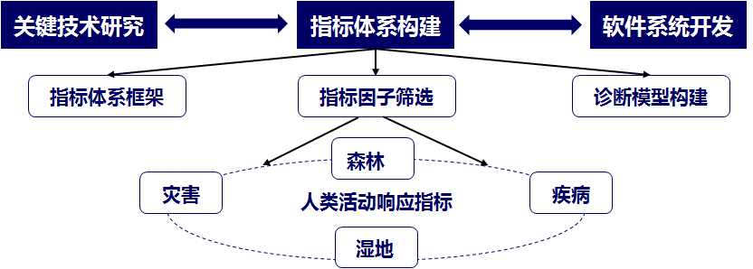
In order to develop scientific and standardized environmental health remote sensing diagnosis "subject, produce more original achievements in scientific research, environmental health research team from remote sensing ecological environment health status, health status, health status of atmospheric water and disaster degree of influence and the human activity in 5 aspects in construction of remote sensing diagnosis index system of environmental health, and on the scientific problems and key study on remote sensing diagnosis technology in environmental health, health diagnosis, remote sensing in the forest wetland remote sensing atmospheric remote sensing health diagnosis, health diagnosis, human activities remote sensing diagnosis of 4 research has obtained remarkable achievements.


Forest health, high precision inversion and estimating optical and laser radar and SAR passive multi-source remote sensing data to realize the forest tree height, DBH, crown width, crown density, leaf area index and biomass based on parameters; to forest fires in Greater Khingan Range as an example, the remote diagnosis and evaluation of post disaster recovery of vegetation the sudden oak death; for example, and in China adaptability of forest pests and risk of outbreaks were predicted for early warning; desertification in Inner Mongolia desert area 5 and 5 Da Sha of remote sensing dynamic monitoring, and analyzes its trend, provide technical support for the sustainable utilization of forest resources and forest health diagnosis.
Wetland health, from the three aspects of health, function, value of wetland ecological system selects 13 indexes and 28 level two indexes, set up a scientific and reasonable, the evaluation index system of wetland ecological system operation is strong, and in the country around the wetland area extraction, wetland ecosystem health assessment and for wetland flood disaster response analysis are carried out a series of demonstration and application form can be used for the actual operation of the "index system" and "technical manual", to fill the gaps in the field of quantitative monitoring and diagnosis of wetland ecosystem in china.
The health of the atmosphere, combined with a comprehensive analysis of multi-source remote sensing and ground data changes in Beijing during the dust storm aerosol optical characteristics and meteorological parameters; the first comparative analysis of satellite aerosol products based on the air pollution index and air quality index; estimate the central area of Beijing long time series PM2.5, and long-term exposure to PM2.5 due to premature deaths. Remote sensing of atmospheric health monitoring enables air monitoring from local to macro, from ground to air.
Human activities, focusing on monitoring and early warning of major infectious diseases in the world, the bird flu spread risk prediction and risk time Chinese partition, the foci of plague cholera classification, analysis, environmental risk factors of HFMD outbreaks of infectious diseases earthquake risk assessment, the global influenza early propagation simulation has done a lot of research and application. Research and development of infectious diseases and visualization prediction software, as a public health emergency response provides spatial information technology support services.
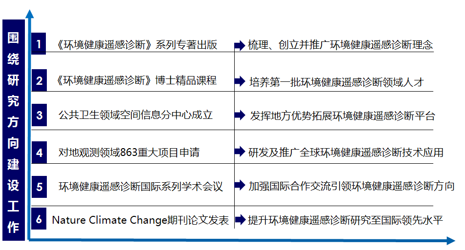
Based on the above research results, the team carried out a comprehensive in-depth research work around the research direction:

Actively explore the well-known experts at home and abroad in the field of research and application of remote sensing based on the potential of collaboration to promote team oriented output international first-class scientific research working principle, construction of a study on remote sensing diagnosis of environmental health international top team.
With the signing of "Environmental Health Science Press", "environmental health diagnosis of remote sensing remote sensing diagnosis index system", "environmental health", "key technology of remote sensing diagnosis environmental health diagnosis system", "remote sensing global environmental health diagnosis", "remote sensing remote sensing China environmental health diagnosis" series of monographs, including first of the "environmental health remote sensing diagnosis" has been published in 2013, the remaining five will also be launched.
In "Science China-Earth Sciences" (China series D) on "Key technologies in application special organization of HJ-1A/B satellite Data (Research on the key technology of HJ-1A/B satellite);" International Journal of "in Remote Sensing" (International remote sensing) on Prior knowledge-based retrieval special organization "and validation of information from remote-sensing data at various scales (inversion and validation of prior knowledge based on multi-scale remote sensing quantitative)".
In 2011-2015, the 5 annual meeting of the International Conference on "environmental health remote sensing diagnosis" was carried out, which promoted the development of cross disciplinary science and technology and the construction of international talent team.
In the past 5 years, the team has undertaken the national major projects, 973, 863, civil aerospace research and development project projects such as 20, across all national scientific research projects in the field of remote sensing, make the corresponding contribution to the development of remote sensing technology in china. Get the software copyright 7, 6 patents, for major national strategic needs put forward the recommendations in the report of 4 were above the provincial level leadership instructions, Liaoning forestry science and Technology Award (2014), a prize, outstanding achievements in survey and Design Institute of State Forestry Bureau of Anshan city science and Technology Progress Award (2013) the 1. The team has made remarkable achievements in data accumulation, hardware equipment research and development, application software research and development, scientific research projects and achievements.
"Environmental health remote sensing diagnosis" team leader Cao Chunxiang researcher has in the local postgraduate training more than 20 employees, including 2 postdoctoral fellows, 11 Ph.D., received a master's degree in 3, graduating students go to the system, China Academy of Sciences and the National Space Agency, the state forestry system; recruit from Thailand, Nepal, Pakistan 7 international students exchange, exchanges and cooperation with the Boston University, the Max Planck Institute, Kyoto University, Hokkaido University, University of Fukui, Japan and other international well-known universities and academic institutions have students; graduate and graduate student scholarship awards including the dean Chinese Academy 1, Chinese academy director scholarship 2, outstanding graduates of Graduate University of Chinese Academy of Sciences. 2, Academy of Sciences at the University of China three good student TITLE 7 people, 1 people three good student model of remote sensing.
Three, the future development of remote sensing of environmental health
In order to put forward the response of Bai Chunli at the 2014 annual meeting of the Chinese Academy of Sciences of the Chinese Academy of Sciences to implement the "first action" plan, efforts to enhance the innovation ability, service innovation driven development; efforts to deepen reforms, stimulate innovation and vitality; efforts to strengthen coordination, promote the all-round development of the international research team, the young the virtual reality from the virtual to the field of public health, with the application of spatial information technology research center as the main carrier, through the integration of environmental health remote sensing field of existing hardware resources, and create a good platform for the initiative to further develop the spatial information technology, ecological environment, public health and other areas of outstanding scholars and young talents. Has been to the superior departments recommended the establishment of "national environmental health remote diagnosis center". "The national environmental health remote sensing diagnosis center will integrate spatial cognition of Silk Road Economic Belt by spatial information technology, regional environment to realize the sharing of information resources, provide technology support and guarantee for the regional environmental protection and sustainable development; at the same time devoted to the analysis and simulation studies in South East Asia infectious disease epidemic spread of infectious diseases to establish disaster time. The forecast and early warning system for public health emergency, Southeast Asian countries to provide technical support for the integration of existing response; environmental health in China related remote sensing, geography, environment, history and current situation of public health data, the formation of more comprehensive environmental health big data, in order to promote the research of remote sensing diagnosis of environmental health in China" big data era "of the play leading role.
